(Canada) – Top things to do in Bay of Fundy

Located off the northern coast of Maine and extending into Canada between New Brunswick and Nova Scotia, the natural phenomenon known as the Bay of Fundy is a 270 km (170 mile) long ocean bay that’s home to the world’s highest tides (54 feet/16m). The Bay of Fundy has a diverse ecosystem and a marine biodiversity comparable to the Amazon Rainforest. Its waters are populated with up to 12 species of whales, an abundance of dolphins, porpoises, fish, seals, seabirds and more.

(Canada) – Top things to do in Bay of Fundy
 
Every day, twice a day 110 billion tonnes of seawater rush into the Bay creating phenomena that can only be experienced to be appreciated. Tides are crucial to this ecosystem and are highly respected by everyone who has seen their effect.  The tide waits for no-one, and life along the Bay is dictated by the ebb and flow of water. 

Below are top things to do around the Bay of Fundy:
1. Whale Watch in the Bay of Fundy
Look for the endangered North Atlantic Right Whale and 6 other species that frequent the Bay of Fundy. Many different whales can be found in the Bay of Fundy in the summer, as it is an abundant feeding ground. Minke whales are plentiful.  You can also find humpbacks, fin whales, and the occasional blue whale.  There are also seals and many types of sea birds in the Bay.

(Canada) - Whale Watch in the Bay of Fundy
2. Walk on the ocean floor

(Canada) - Bay of Fundy - Walk on the ocean floor
 
Walk on the ocean floor and explore the tidal pools where the highest tides in the world have been recorded. Although many places claim to have the highest tides in the world, tides at Burntcoat Head are actually the highest, averaging 55.8', with the highest being set during the 1869 Saxby Gale at 70.9'

(Canada) - Bay of Fundy - Walk on the ocean floor
Visit Hopewell Rocks, located on the New Brunswick side of the Bay of Fundy. At low tide, explore quiet coves with flowerpot-shaped rock formations bearing such curious names as 'Mother-in-Law', 'ET' and 'Lover's Arch'.

(Canada) - Bay of Fundy - Walk on the ocean floor
3. Cape d’Or
With rugged red-colored vertical cliffs on either side and sparkling water stretching out as far as the eye can see Cape d'Or bears testimony to the awesome power of nature.  It has the distinction of being the only place in the world where three tides converge, meeting simultaneously to create violent riptides-a phenomenon known as the Dory Rips. The lookout platform affords views of Cape Split and Ile Haute Island.

(Canada) - Bay of Fundy - Cape D'Or Lighthouse
4. Tidal Bore Rafting
At first, the Shubenacadie River seems like a very lazy river. Situated amid 200-foot-high gypsum cliffs, it starts out as a relaxing paddle past mudflats and sandbars until you reach the mouth of the river, where the tides from the Bay of Fundy come rushing in. Suddenly, you're white-water rafting on the world's highest tides, which travel inland at roughly 50 km an hour and stir up sixteen-foot waves.

(Canada) - Bay of Fundy - Tidal Bore Rafting
5. Hall’s Harbour
Hall's Harbour is a fishing port that works to the ever changing rhythm of the 40 foot Fundy tides. Snugly settled in its picturesque cove, and guarded on each side by tall basalt cliffs, the harbour's inner basin fills twice a day to the top of the towering wharves. Six hours later the water recedes far out into the Bay of Fundy leaving the colourful fleet of vessels dry on the harbour floor.  Beach comb for treasures and watch the landscape change as the tide comes and goes.

(Canada) - Bay of Fundy - Hall’s Harbour
(solotravelerblog.com, bayoffundyfuntours.com, en.wikipedia.org)
»»  READMORE...

(New Zealand) – Visiting Milford Sound

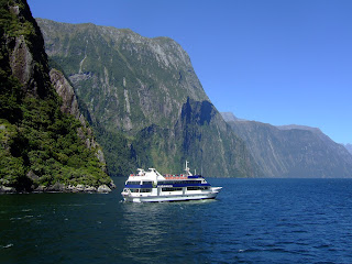
Milford Sound, located in the southwest of New Zealand’s South Island, is located within the Fiordland National Park. It runs 15 km inland from the Tasman Sea and is surrounded by sheer rock faces that rise 1200 m or more on either side. Among its most striking features are Mitre Peak, rising 1,692 m above the sound, the Elephant at 1,517 m and resembling an elephant’s's head, and Lion Mountain, 1,302 m, in the shape of a crouching lion. Lush rain forests cling precariously to these cliffs, while seals, penguins and dolphins populate the water.

(New Zealand) – Visiting Milford Sound
 The beauty of this landscape draws thousands of visitors each day, with between 550,000 and 1 million visitors in total per year. This makes the sound one of New Zealand's most-visited tourist spots, and also the most famous New Zealand tourist destination, even with its remote location and the long journey from the nearest population centre. Almost all tourists going to the sound also take one of the boat tours which usually last between 1–2 hours. They are offered by several companies, departing from the Milford Sound Visitors' Centre. There is also the option of extended overnight cruises on Milford Sound.

Tramping, canoeing and some other water sports are also possible. A small number of companies also provide overnight boat trips. There is otherwise only limited accommodation at the Sound, and only a very small percentage of tourists stay more than the day.

(New Zealand) - Milford Sound Map


An underwater tourist observatory found in one of the bays of the sound provides viewing of black coral, usually only found in much deeper waters. A dark surface layer of fresh water, stained by tannins from the surrounding forest, allows the corals to grow close to the surface here.

In rainy and stormy days tourists can admire the play of the wind with the numerous waterfalls in Milford Sound. When meeting the cliff face the powerful wind often goes upward and waterfalls with a vertical drop get caught by wind, causing the water to go upwards.

Things to do in Milford Sound
Milford Sound Cruises
A range of day and night cruises will take visitors to see the attractions of Milford Sound, including the native wildlife, dramatic waterfalls, Mitre Peak and the Underwater Observatory at Harrison Cove. All day cruises depart from the wharf complex, a short walk from the Mitre Peak Café and carpark.

(New Zealand) - Milford Sound Cruises

Mitre Peak
This towering rock face - said to resemble a Bishop's mitre - is one of Milford Sound's most famous sights, rising 1695m from the serene waters.

(New Zealand) - Mitre Peak Milford Sound

Milford Sound Underwater Observatory
Located 9m underwater, this circular observation gallery has windows which look out over the heart of the fiord. Specially cultivated window-box gardens contain rare black corals which usually only grow at levels deeper than 40m. Visitors can see brightly coloured fish, sea fans, giant starfish, tubeworms - and, if they are lucky, the odd seal or shark may swim by.

(New Zealand) - Milford Sound Underwater Observatory

Milford Track
Said to be one of the finest walks in the world, the Milford Track (54km) takes in pristine rainforest and crystal-clear streams. The four-day track starts at Glade House, at the northern end of Lake Te Anau. From here, it pases through rainforest, over the dramatic Mackinnon Pass, down to Quintin Hut and through Arthur River Valley to Milford Sound. Walkers can enjoy breathtaking views from the top of Mackinnon Pass, or make the return walk from Quintin Hut to the beautiful Sutherland Falls.

(New Zealand) - Milford Track

Sutherland Falls
New Zealand's highest waterfall cascades 630m down a sheer rockface. The falls were named after Milford Sound's earliest settler, Scotsman Donald Sutherland, who established the area's first accommodation upon his arrival in 1877.

(New Zealand) - Sutherland Falls


(wikipedia.org, jasons.co.nz)
»»  READMORE...

(Australia) –Getting to Uluru (Ayers Rock)

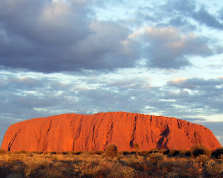
Uluru (Ayers Rock) is one of Australia's most recognizable natural icons. The world-renowned sandstone formation stands 348 m high above sea level with most of its bulk below the ground, and measures 9.4 km in circumference. Uluru appears to change color as the different light strikes it at different times of the day and year.

(Australia) –Getting to  Uluru (Ayers Rock)
(Australia) –Getting to  Uluru (Ayers Rock)
 
What to see
Uluru is an isolated sandstone rock (not technically a monolith) that stands 346 meters high and more than 8 km (5 miles) around. Roughly triangular in shape, it stretches for over 2 miles in length and nearly 2 miles in width. It has a harder exterior than most other rock formations, which allows for the unusually steep rock faces all the way to ground level.

Uluru is a completely bare rock without the least bit of vegetation, which only adds to its stark and mysterious beauty. By great contrast, however, the base of the rock is nourished by rain runoff from Uluru and is a fertile oasis of water pools, rich greenery and a variety of wildlife. It is thus an ideal ceremonial site for the Aborigines, who camp in the caves and are sustained by the water and available food.

Aside from its imposing size the most impressive feature of Uluru, beloved by Aborigines and visitors alike, is its beautiful range of changing colors throughout the day and year. Sunrise and sunset are particularly remarkable, with the rock glowing a deep rusty red. The rock derives its rust colour from oxidation, and the glowing effect at sunrise and sunset is due to the arkosic sandstone of the rock, which contains reflective minerals and changes color according to the attitude of the sun.

(Australia) –Getting to  Uluru (Ayers Rock)
(Australia) –Getting to  Uluru (Ayers Rock)

 Ayers Rock contains a variety of interesting cracks, canyons, caves and natural formations, all of which the Anangu attribute to the activities of ancestral beings at the creation time. The shallow caves at the base of the rock contain ancient carvings and paintings. But unlike the Lascaux Caves and other cave art sites, the Uluru rock drawings are just not artifacts of some distant culture — they are still being created by the Anangu.

At Uluru, the old cave drawings are simply painted over with new ones, and the paint is made largely of water and is therefore quite delicate. For these reasons, the rock art in these caves is impossible to date with any certainty. The rock art includes figures like boomerangs, human beings, waterholes and abstract symbols.

The base walk around the perimeter of Uluru is 9.4 km long. There is also a Mala Walk (2 km) and Mutitjulu walk (1 km). Guided walking tours are available from park rangers and by the Anangu themselves. These are popular activities and are encouraged by the Anangu. However, the most popular thing to do at Uluru is to climb it (see Making the Climb, below).

About 25 km from Uluru is another sacred rock formation known as Kata Tjuta (“many heads”) or the Olgas (named for Queen Olga of Württemberg in 1872). Special viewing areas with road access and parking have been constructed to give tourists the best views of both sites at dawn and dusk. The Uluru-Kata Tjuta National Park also includes a Cultural Center, where you can learn more about Aboriginal culture and the sacredness of Uluru.

(Australia) –Getting to  Uluru (Ayers Rock)
(Australia) –Getting to  Uluru (Ayers Rock)

 The Aboriginal community of Mutitjulu (pop. approx. 300) is near the western end of Uluru. From Uluru it is 17 km by road to the tourist town of Yulara (pop. 3,000), which is situated just outside of the National Park. Ayers Rock Resort just outside the park has accommodation for a wide range of budgets. The buildings of the tourist resort are colored to blend in with the surrounding desert.

Getting there
The most common journey to Ayers Rock begins at Alice Springs, from which it is 280 miles (450 km) southwest by road to the site. You can drive yourself, take a bus or join a tour from Alice Springs. See map below.

Flights depart daily from most capital cities to Connellan Airport, which is located just outside the Park. Contact a travel agent for further details. Car hire is available from the airport and is best arranged through a travel agent before arrival.

(Australia) –Getting to  Uluru (Ayers Rock)
(Australia) –Getting to  Uluru (Ayers Rock)
 
Our tour partner Viator offers a variety of tours, walks, transportation options, night shows and workshops that you can book ahead in your own currency

Quick Facts
Site information:
Name:                             Uluru (Ayers Rock)
Location:                         Northern Territory, Australia
Faith:                               Indigenous
Denomination:                  Aboriginal
Categories:                      Sacred Rocks; Rock Art; World Heritage Sites
Size:                                1,100 feet (335 meters) high; 2.2 miles (3.6 km) long; 1.5 miles (2 km) wide
Features:                         Petroglyphs
Status:                             Active
Visitor information:
Address:                         Uluru-Kata Tjuta National Park, PO Box 119, Yulara NT 0872 Australia
Coordinates:                   25.344722° S, 131.0325° E
Phone:                            Park administration: (+61) 8 - 8956 1100
                                      Cultural Center: (+61) 8 - 8956 1128
Website:                         www.deh.gov.au/parks/uluru/
Email:                             uluru.info@deh.gov.au
Opening hours:               Open during daylight hours, including sunrise and sunset.
Cost:                              Free

(crystalinks.com, new7wonders.com, en.wikipedia.org, sacred-destinations.com)
»»  READMORE...