Showing posts with label South America. Show all posts

(Argentina & Brazil) - Iguazú Falls - Walking on the footbridge and Wild Adventure

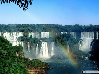
Iguazu Falls is undoubtedly the most visited place in Misiones and one of the most imposing natural attractions in Argentina, and why not in South America.

(Argentina & Brazil) - Iguazú Falls - Walking on the footbridge and Wild Adventure
 Together with Nahuel Huapi National Park in Patagonia, it is one of the most frequented tourist sites.
In guarani language, the term "Iguazú" means "great waters". It was discovered in 1541 by Alvar Núñez Cabeza de Vaca and established in 1984 as Natural World Heritage Site by UNESCO.

Situated in Iguazú National Park, some 20 km. from Puerto Iguazú in the north of the province, these falls are shared by Brazil and Argentina.

Iguazú river is born in Paraná state in Brazil, and after crossing 1,200 km. on a plateau where it receives several affluents, it reaches a fault forming a crack in the interleaved layers of sandstone and basalt where the river runs.

This river runs through a smooth geography until it reaches a series of faults, and suddenly an 80 m. canyon in the Devil's Throat where the water produces a thundering sound and then drains into the Parana river.

A legend says that a big snake called "Boi" lived in the river. To calm its ferocity, aborigines sacrificed a woman every year as an offering. But once a brave guarani aborigin kidnapped the woman and saved her from the traditional rite escaping through the river. Boi burst in anger, bent its body and split the river forming the cataracts separating the man and the woman.

Walking on the footbridge
There are more than 270 falls in an area where cliffs and islets are scattered in a half moon.
From the visitors center you can walk around trails or in a picturesque train.
There are two basic circuits: an upper path and a lower path.

(Argentina & Brazil) - Iguazú Falls - Walking on the footbridge and Wild Adventure
 The lower path leads to the base of the falls, where the spray moistens visitors. It is a unique experience, worth daring the adventure. In this circuit you may also take a boat to Isla San Martín.
From the upper path you have panoramic views from the footbridge in an unforgettable experience.

The falls that can be visited are: Salto Floriano, Salto Deodoro, Salto Benjamín Constant, Salto Unión, Salto Escondido, Salto Mitre, Salto Belgrano, Salto Rivadavia, Salto Tres Mosqueteros, Salto Dos Mosqueteros, Salto San Martín, Salto Adán y Eva, Salto Bozzetti, Salto Ramirez, Salto Chico, Salto Dos Hermanos and Salto Alvar Nuñez .

(Argentina & Brazil) - Iguazú Falls - Walking on the footbridge and Wild Adventure
 
Leaving from Cataratas station, we go to the footbridge on the upper part of the river. We get to the balcony on the Devil's Throat, the biggest fall with such a big flow of water that you will be overcome by the grandeur of the scenery.

Wild Adventure
The lovers of adventure travelling can acces to more intense circuits.

Apart from waterfalls, the jungle offers a series of alternatives in a dump but slightly fresher environment with a wide variety of animals and plants. Almost 500 species of wild fowl, 80 species of mammals and an immense variety of reptiles, fish, insects and butterflies live in this ecosystem.
(Argentina & Brazil) - Iguazú Falls - Walking on the footbridge and Wild Adventure

 Only some meters from the Research Center is Macuco Trail, a 3 km. walking path through the dense jungle with different degrees of difficulty. It is a 2 hour walk to Salto Arrechea.

A private operator offers a more daring alternative. Leaving in a 4x4 vehicle we drive 8 km. through the jungle to the coast of the inferior Iguazu river.
Some semi-rigid rafts with powerful engines will be waiting for us to go upstream and into the mist veil formed by the cascades.

Another option is to take a rowing boat in the upper Iguazú river to watch the animals and plants in this delta, and maybe see some water tortoises or yacares sunbathing on the coast.

Iguazú is a singular environment that inspired the writer Horacio Quiroga in his "Tales of the Jungle".

(welcomeargentina.com, en.wikipedia.org, gosouthamerica.about.com)
»»  READMORE...

(South America) – Amazon - World’s largest tropical rainforest and river basin

The Amazon rainforest is huge, and you can enter from several different countries in South America.

South America - Amazon - World's largest tropical rainforest and river basin
 
The landscape contains:
- One in ten known species on Earth
- 1.4 billion acres of dense forests, half of the planet’s remaining tropical forests
- 4,100 miles of winding rivers, the source of almost one-fifth of all free-flowing fresh water on Earth
- 2.6 million square miles, about 40 percent of South America, in the Amazon Basin

South America - Amazon - World's largest tropical rainforest and river basin

The easiest countries to enter from are Ecuador and Brazil. To enter from Ecuador , take an international airline to Quito . From Quito travel to the Amazon rainforest, by bus, small plane or private guide. Quito is a unique city, rich in history which should be explored if time permits. To enter from Brazil , you can easily find flights from all over the world to Sao Paulo and Rio de Janeiro . If you have time spend a few days in those cities if you want, especially Rio which is famous for its carnival parade in February. From Sao Paulo or Rio you can get another flight to the Amazon cities, you can choose among many state capital cities like Manaus , Belem , Macapa, Boa Vista , Porto Velho or Rio Branco . Manuas and Belem have the most infrastructures for tourists.

South America - Amazon - World's largest tropical rainforest and river basin

In the Amazon rainforest you can travel in small airplanes (very nice to get an aerial view) between the smaller cities. But on the ground level there is just one way to travel in the Amazon rainforest, which is by boat. The Amazon rainforest is full of rivers, from the smallest one to the biggest one on the planet. The Amazon River is responsible for 25% of the fresh water that goes into the oceans. The Amazon River is so big that in some places you can't see the other side of the river. Certain areas seem just like an ocean since you have white sand beaches and waves! In some places the rivers edges are 30 miles from each other.

(South America - Amazon) Scarlet Macaw Flying
 The size of the boats depends on how far you are going. For smaller day-trip travel the usual boat is called "Voadeira" (the best translation it would be "Flyer Boat") which are small aluminum boats for just a dozen people with stern nautical engines, they are very common, fast and you can go in most places in a voadeira boat.

(South America - Amazon) Scarlet Macaw Flying
(South America - Amazon) Old Growth Rainforests Amazon Conservation
If you are going to make a longer trip you will use wooden boats that vary in size but sometimes can carry hundreds of passengers. In these boats you can pay for a cabin (on some of the better boats air conditioning is offered, this will make your trip more pleasant through the Amazon rainforest). If you can't or don't want to pay for the cabin, you will travel the way the local do, with nets! Yes, for the common Amazon man and woman when they travel for long distances they sleep in nets, they are very used to it since a net is one of the most common things in the region. If you are adventurous enough and like to travel like the local population, this is your way and it's much cheaper (although the cabin is not expensive).

South America - Amazon - World's largest tropical rainforest and river basin
Longer trips are a very nice way to get to know the region. You can go from Manaus to Santarem (a medium size city) or from Belem to Santarem by boat. These boats have regular schedules and it's safe. You can also go from Belem to Manaus (and vice-versa ) but then you would spend a week in a boat, to Santarem it will be only a few days and there you have an airport with direct flights to the Amazon region capitals or other cities in Brazil like Brasilia ( capital of the country) or even Rio de Janeiro . On the largest boats you can eat and take small foot tours in the small villages they stop by on the way up the river.

Along with the big boats and the voadeiras, canoes are very common and are the local population's most important way of transport. Canoes can be used for small trips or to go deep in small rivers. These canoes are hand made by Indians, or local individuals that learn from Indians, using Amazon rainforest wood and although they were originally conceived to be propelled by paddles, nowadays people use small engine propellers. Going deep in a small river branch in a paddle canoe is an incredible experience. You are almost completely covered with the rain forest canopy and you can feel and hear the Amazon rainforest in all its greatness.
(amazon-rainforest.org; en.wikipedia.org; worldwildlife.org)
»»  READMORE...

(Bolivia) - Salar de Uyuni: A Mirror That Reflects The Sky


Salar de Uyuni is with its 10,580 km² (4,084 square miles) the world's largest salt flat. It is an arid, windswept salt flat in southwestern Bolivia. It lies on the Altiplano, at 3656 m (11,995 f) above sea level. Salar de Uyuni is estimated to contain 10 billion tons of salt of which less than 25,000 tons is extracted annually. The major minerals found in the salar are halite and gypsum. The salt is over 10 meters thick in the center. In the dry season, the salt planes are a completely flat expanse of dry salt giving it a appearance of frozen arctic sea, but in the wet season (November-April), it is covered with a thin sheet of water of varying depth. It is surrounded by volcanoes of which the Mt. Tumupa at the northern shore is the most dominating. There are also several so-called islands which provide spectacular scenery, two of the most famous ones are Fish Island (Isla Cujiri) and Fishermens Island (Isla Inkawasi).

Salar de Uyuni - Bolivia

It is a place where the salt flats reflect the sky. It is the world’s largest mirror created by more than 4,000 square miles in the “Potosí and Oruro departments in southwest Bolivia, near the crest of the Andes.”
And it is breathtaking. Salar de Uyuni is a place where nature rules majestically and reflects snow-covered mountains which reflect off the salt covered in water. During the dry season, salt lies the area but when the rains come, it is the gods’ mirror of exquisite and finite grace and elegance.

Salar de Uyuni - Bolivia


How to get there
Rail from Oruro, Bolivia
Bus (including a tourist bus) from Oruro, Potosi, or La Paz, Bolivia.

Salar de Uyuni - Bolivia
(Collect from: boliviaexperience.com, stumbleupon.com, wikitravel.org)
»»  READMORE...

(Peru) - Exploring the Uros Floating Islands


Most visitors to Peru focus on exploring the Uros Floating Islands. More than 40 unique floating islands can be found on Lake Titicaca, the highest navigable lake in the world some 12,000 feet above sea level, and also South America’s largest lake. Located in the South eastern part of Peru near the city of Puno, the far side of the lake is bordered by Bolivia.

Uros Floating Islands - Peru
These islands are made and inhabited by the Uros people, who settled in the middle of the lake and started their strange lifestyle as a mean to avoid confrontations with the more powerful Collas and Incas. Uros, however, have long been intermarrying with Aymara Indians, so nowadays it would be more precise to refer to the families that inhabit the totora-reed islands as Uro-Aymaras.

Uros Floating Islands - Peru

The larger and most visited islands appear to many travellers as floating souvenirs, and to some extent these indeed are tourist-traps, their inhabitants having succeed in living off tourism. However, most of the smaller islands remain isolated from visitors and still practice a traditional way of life that includes old-technique fishing, bird-trapping, and relying on totora for housing and transportation.

Getting to the Floating Islands

Flying into the nearest airport in Juliaca is possible but the more intrepid Peru traveler may choose to explore the country more intensely by flying into Lima and then taking several days and various modes of transportation to truly experience the flavor of the countryside, the people and the culture.

Uros Floating Islands - Peru

Following the winding narrow roads of Peru into the mountains and into the small town of Puno, so high above sea level almost touching the clouds, the spectacular expanse of Lake Titicaca that greets visitors rounding the corner coming out of town is postcard perfect. There’s not much to see in Puno so most travelers head straight to the lake to the floating islands nestled amongst the natural islands of Taquile and Amantani. None of the islands, natural or man-made, have any cars or roads, only footpaths and peace and tranquility. The lake is a very spiritual place as it is believed that Manco Capac, the original Inca chieftain, rose from the waters of Lake Titicaca to create the Incan Empire.

Uros Floating Islands - Peru

Lake Titicaca's Islands of Reed

The floating islands are made by hand from tortora reeds by the Quechua and Aymara Indians that inhabit the islands and welcome visitors, even for overnight stays so they can experience the simple lifestyle of the natives. The amenities are limited. However, there is the odd hut sporting a satellite dish precariously perched atop its thatched roof alongside the solar panels that power the rare televisions. The same type of reed is also used to make the island dwellers’ homes and boats. Reed boats take travelers from one floating island to the next with a special visit to the largest one where the school house sits.

The Inca Experience

Many visitors wrap up their visit on the lake with lunch on Taquile where the only footpath from the dock leads them on a steep journey through Inca and pre-Inca stone ruins and terraced farms into town where the local children adorn newcomers with friendship bracelets they’ve woven by hand, which are said to bring good luck. Plans should be made in advance since, with enough warning, lunch is typically prepared and served in one of the local’s homes. There are a few very simple restaurants near the central plaza but the home-cooked meal and hospitality is the favored experience.

Uros Floating Islands - Peru

Best times to visit are February or November when the Semana de Puno festivities celebrating the Inca culture are in full swing and Peruvian folklore is celebrated.

(Collect from: suite101.com and theperuguide.com)

»»  READMORE...