Showing posts with label new 7 wonders. Show all posts

(Vietnam) – Enjoy full memories in Halong Bay

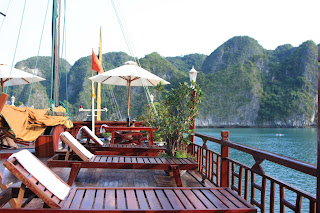
Ha Long Bay is located in the northeastern part of Vietnam and constitutes part of the western bank of Bac Bo Gulf, including the sea area of Ha Long City and Cam Pha Town and part of Vân Don island district. It abuts Cat Ba Island in the southwest. Toward the west is the shore with a 120 km-long coastline. It is located within 106o58’-107o22’ east longitude and within 20o45’- 20o50’ north latitude. The site is 1553 sq. km with 1969 islands of various sizes, of which 989 have been named.

(Vietnam) – Enjoy full memories in Halong Bay

 The islands in Ha Long Bay are mainly limestone and schist islands most lying in the two main areas: the southeastern part of Bái T Long Bay and southwestern part of H Long Bay. These islands represent the most ancient images of a geographical site having a tectonic age of from 250 million to 280 million years. They are the result of many times of rising and lowering processes of the continent to form a karst. The process of nearly full erosion and weathering of the karst created the unique H Long Bay in the world. In a not very large area, thousands of islands with different forms look like glittering emeralds attached to the blue scarf of a virgin. The area where many stone islands concentrate has spectacular scenes and world-famous caves and is the center of Ha Long Bay Natural Heritage, including HaLong Bay and a part of Bái Tu Long Bay.

(Vietnam) – Enjoy full memories in Halong Bay


The area is recognized as the World Natural Heritage that is the area of 434 sq. km with 775 islands. It looks like a giant triangle with Ðu G Island (in the west), Ba Hm Lake (in the south) and Cng Tây Island (in the east) as its three angle points. The nearby area is the buffer area and areas classified as national beauty spots in 1962 by the Ministry of Culture and Information.

(Vietnam) – Enjoy full memories in Halong Bay

 Viewed from above, H Long Bay looks like an extremely vivid huge drawing. This is a wonderful and skilful masterpiece of the Creation and of nature that turns thousands of dumb soulless stone islands into fantastic sculptural and artistic works of various graceful shapes, both familiar and strange to human beings. Thousands of islands emerging uneven in the fanciful waves look strong and magnificent but also mild and vivid. Amidst these islands we feel as if we were astray in a petrified legendary world.

(Vietnam) – Enjoy full memories in Halong Bay
 
There are many names given to islands according to their shapes and forms. This one looks like somebody heading toward the shore: Hòn Ðu Người (Human Head Island); that one looks like a dragon hovering above the sea surface: Hòn Rông (Dragon Island); another looks like an old man sitting fishing: Hòn Lã Vng; some look like big sails struggling amidst the wind to set off for the sea: Hòn Cánh Bum (Sail Island); then two islands look like a pair of chicken lovingly playing with each other above the sea: Hòn Trng Mái (Male and Female Chicken Island); and amid the vast sea stands an island like a big incense burner like a ritual offering to Heaven: Hòn Lư Hương (Incense Burner Island). All are so real that people are taken aback by them. Those stone islands have experienced unpredictable changes over time and they take different shapes from different angles of view. Here, we come to realize that they are not dumb inanimate things but are vivid and soulful.
(Vietnam) – Enjoy full memories in Halong Bay

 Inside the stone islands are various breath-taking caves, such as Thiên Cung, Ðu G, Sng St, Trinh N, Tam Cung and others. These are really magnificent palaces of the Creation on earth. Long ago, H Long Bay has been called by the great national poet Nguyn Trãi:“a wonder of the earth erected towards the high sky”. Many men of letters from all over the world have been taken aback at the grandiose scenery of H Long. They seem to get puzzled and incompetent as their treasure of vocabulary is not rich enough to depict the splendor of this place.

(Vietnam) – Enjoy full memories in Halong Bay

 H Long Bay is also attached to glorious pages of Vietnamese history, with famous sites such as Vân Ðn, a bustling trade port in the 12th century, charming Bài Thơ Mountain, and not very far away from here is the Bch Đng River which witnessed two famous naval battles of the Viêt’s ancestors against invaders. Also, H Long is one of the cradles of human kind with the glorious H Long culture in the late Neolithic age, discovered at such archeological sites as Ðng Mang, Xích Th, Soi Nh and Thoi Giếng.

(Vietnam) – Enjoy full memories in Halong Bay

 H Long is also home to great biodiversity with typical eco-systems like mangrove forest, coral and tropical forest. It is also home to thousands of plants and animals of numerous species, for example shrimp, fish and squid. Some species are particularly rare and can be found no where else.

(Vietnam) – Enjoy full memories in Halong Bay
 
With such special values, at the 18th Session of UNESCO’s Council of World Heritage held on 17 December 1994 in Thailand, H Long Bay was officially placed on the list of the World Natural Heritage. In 2000, UNESCO recognized it as the World Heritage for the second time for its geographical and geomorphologic values. This confirms the global premier value of H Long Bay.

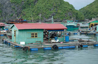
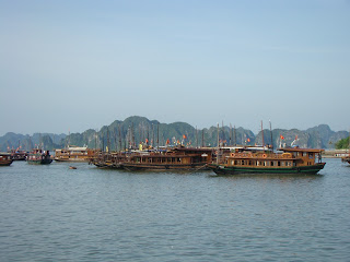
(Vietnam) - Halong Bay - Floating Village
(Vietnam) - Halong Bay Floating Village


(halongtravelguide.com)
»»  READMORE...

(South Africa) - Table Mountain - The Landmark of Cape Town

Table Mountain, Afrikaans Tafelberg, is a flat-topped mountain forming a prominent landmark overlooking the city of Cape Town in South Africa, and is featured in the flag of Cape Town and other local government insignia. It is a significant tourist attraction, with many visitors using the cableway, campaign, or hiking to the top and other activites. The mountain forms part of the Table Mountain National Park.

(South Africa) - Table Mountain - The Landmark of Cape Town
The mountain is sculpted from sandstone and rises 1086 metres at its highest point, Maclears Beacon, above the bay. Its flat summit measures nearly 3km and provides breathtaking views over the city and its beaches. The panorama stretches from Table Bay to False Bay and around the mountain to the Hout Bay Valley and Kommetjie. On a clear day one has a magnificent view across the Cape Flats to the Hottentots Holland Mountains.

Table Mountain is home to a rich fauna and flora, many species of which are endemic and survive only in the unique ecosystem which is contained on the mountain. There are approximately 1470 species of plants, including over 250 different species of daisies! Examples of endemic plants are the rare Silver Tree and the wild orchid Disa Uniflora. Animals such as baboons and porcupines live here freely, as well as furry rodents called Rock Dassies. These little creatures look like plump rabbits without ears - incredibly, their closest living relative is the elephant! The Table Mountain Ghost Frog is an example of an animal found in no other place on the world.

(South Africa) - Table Mountain - The Landmark of Cape Town
The exhilerating ascent of Table Mountain in the cable car is a definite must for any visitor. Even the locals are awed time and again by the 360º view of Cape Town from the cable car. The cable car was first opened in 1929 and today conveys some 600,000 people to the summit annually. On the summit there is a Cape Town restaurant and a souvenir shop, from which letters bearing the Table Mountain postmark can be sent. Short walks from the cable station take visitors through the splendour of the flora of Table Mountain, punctuated by occasional sightings of dassies and framed by the surrounding azure of the Atlantic Ocean.

For those athletic and energetic types, there are some 350 recognised paths to the summit, some undemanding and suitable for children, and some extremely difficult. It is not advisable that visitors climb the mountain without an experienced guide. The mountain can be deceptive and it is strongly recommended that visitors contact the Mountain Club of South Africa on 021-4653412 before embarking on a hike or climb.

Table Mountain is flanked on the east by the legendary Devil's Peak. As the story goes Van Hunks, a pirate in the early 18th century, retired from his eventful life at sea to live on the slopes of Devil's Peak. He spent his days sitting on the mountain, smoking his pipe. One day a stranger approached him, and a smoking contest ensued which lasted for days. The smoke clouds built up and a strong wind blew them down towards the town. When Van Hunks finally won the contest, the stranger revealed himself to be the Devil (hence Devil's Peak), and the two disappeared in a puff of smoke. Legend says that the cloud of smoke they left became Table Mountain's tablecloth - the famous white cloud that spills over the mountain when the south-easter blows in summer.

(South Africa) - Table Mountain - The Landmark of Cape Town
 
Of course, the phenomenon is also supported by a meteorological explanation. The moisture-laden south-easter blows against Table Mountain from over the False Bay and rises. At a height of approximately 900 meters the winds reach the colder layers of air and thick clouds form. These clouds roll over the mountain and down towards the City Bowl. The characteristic tablecloth forms when the clouds reach the warmer, lower air layers and dissolve once more.

To the right of Table Mountain, Kloof Nek is linked to the aptly named Lion's Head. The spiral walk up Lion's Head passes through silver trees and spring flowers, and provides a 360º view of the Cape Peninsula as you go round the mountain. The walk is not terribly challenging, and is a popular family outing. At the top, you are rewarded with a breathtaking panoramic view, and birds scramble for the crumbs left behind by numerous picnic baskets.

Lion's Head in turn is connected by a lion's body to the rump known as Signal Hill. Signal Hill derives its name from the time when it was used as a semaphore post for communication with ships at sea. It is from here that the noon cannon is still fired every day. After dark, the hill is a popular scene for couples who enjoy the romantic sight of the sparkle of the city lights with the backdrop of a floodlit Table Mountain.

(en.wikipedia.org, britannica.com, cape-town.info)
»»  READMORE...

(Argentina & Brazil) - Iguazú Falls - Walking on the footbridge and Wild Adventure

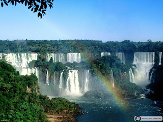
Iguazu Falls is undoubtedly the most visited place in Misiones and one of the most imposing natural attractions in Argentina, and why not in South America.

(Argentina & Brazil) - Iguazú Falls - Walking on the footbridge and Wild Adventure
 Together with Nahuel Huapi National Park in Patagonia, it is one of the most frequented tourist sites.
In guarani language, the term "Iguazú" means "great waters". It was discovered in 1541 by Alvar Núñez Cabeza de Vaca and established in 1984 as Natural World Heritage Site by UNESCO.

Situated in Iguazú National Park, some 20 km. from Puerto Iguazú in the north of the province, these falls are shared by Brazil and Argentina.

Iguazú river is born in Paraná state in Brazil, and after crossing 1,200 km. on a plateau where it receives several affluents, it reaches a fault forming a crack in the interleaved layers of sandstone and basalt where the river runs.

This river runs through a smooth geography until it reaches a series of faults, and suddenly an 80 m. canyon in the Devil's Throat where the water produces a thundering sound and then drains into the Parana river.

A legend says that a big snake called "Boi" lived in the river. To calm its ferocity, aborigines sacrificed a woman every year as an offering. But once a brave guarani aborigin kidnapped the woman and saved her from the traditional rite escaping through the river. Boi burst in anger, bent its body and split the river forming the cataracts separating the man and the woman.

Walking on the footbridge
There are more than 270 falls in an area where cliffs and islets are scattered in a half moon.
From the visitors center you can walk around trails or in a picturesque train.
There are two basic circuits: an upper path and a lower path.

(Argentina & Brazil) - Iguazú Falls - Walking on the footbridge and Wild Adventure
 The lower path leads to the base of the falls, where the spray moistens visitors. It is a unique experience, worth daring the adventure. In this circuit you may also take a boat to Isla San Martín.
From the upper path you have panoramic views from the footbridge in an unforgettable experience.

The falls that can be visited are: Salto Floriano, Salto Deodoro, Salto Benjamín Constant, Salto Unión, Salto Escondido, Salto Mitre, Salto Belgrano, Salto Rivadavia, Salto Tres Mosqueteros, Salto Dos Mosqueteros, Salto San Martín, Salto Adán y Eva, Salto Bozzetti, Salto Ramirez, Salto Chico, Salto Dos Hermanos and Salto Alvar Nuñez .

(Argentina & Brazil) - Iguazú Falls - Walking on the footbridge and Wild Adventure
 
Leaving from Cataratas station, we go to the footbridge on the upper part of the river. We get to the balcony on the Devil's Throat, the biggest fall with such a big flow of water that you will be overcome by the grandeur of the scenery.

Wild Adventure
The lovers of adventure travelling can acces to more intense circuits.

Apart from waterfalls, the jungle offers a series of alternatives in a dump but slightly fresher environment with a wide variety of animals and plants. Almost 500 species of wild fowl, 80 species of mammals and an immense variety of reptiles, fish, insects and butterflies live in this ecosystem.

(Argentina & Brazil) - Iguazú Falls - Walking on the footbridge and Wild Adventure

 Only some meters from the Research Center is Macuco Trail, a 3 km. walking path through the dense jungle with different degrees of difficulty. It is a 2 hour walk to Salto Arrechea.

A private operator offers a more daring alternative. Leaving in a 4x4 vehicle we drive 8 km. through the jungle to the coast of the inferior Iguazu river.
Some semi-rigid rafts with powerful engines will be waiting for us to go upstream and into the mist veil formed by the cascades.

Another option is to take a rowing boat in the upper Iguazú river to watch the animals and plants in this delta, and maybe see some water tortoises or yacares sunbathing on the coast.

Iguazú is a singular environment that inspired the writer Horacio Quiroga in his "Tales of the Jungle".

(welcomeargentina.com, en.wikipedia.org, gosouthamerica.about.com)
»»  READMORE...

(South America) – Amazon - World’s largest tropical rainforest and river basin

The Amazon rainforest is huge, and you can enter from several different countries in South America.

South America - Amazon - World's largest tropical rainforest and river basin
 
The landscape contains:
- One in ten known species on Earth
- 1.4 billion acres of dense forests, half of the planet’s remaining tropical forests
- 4,100 miles of winding rivers, the source of almost one-fifth of all free-flowing fresh water on Earth
- 2.6 million square miles, about 40 percent of South America, in the Amazon Basin

South America - Amazon - World's largest tropical rainforest and river basin

The easiest countries to enter from are Ecuador and Brazil. To enter from Ecuador , take an international airline to Quito . From Quito travel to the Amazon rainforest, by bus, small plane or private guide. Quito is a unique city, rich in history which should be explored if time permits. To enter from Brazil , you can easily find flights from all over the world to Sao Paulo and Rio de Janeiro . If you have time spend a few days in those cities if you want, especially Rio which is famous for its carnival parade in February. From Sao Paulo or Rio you can get another flight to the Amazon cities, you can choose among many state capital cities like Manaus , Belem , Macapa, Boa Vista , Porto Velho or Rio Branco . Manuas and Belem have the most infrastructures for tourists.

South America - Amazon - World's largest tropical rainforest and river basin

In the Amazon rainforest you can travel in small airplanes (very nice to get an aerial view) between the smaller cities. But on the ground level there is just one way to travel in the Amazon rainforest, which is by boat. The Amazon rainforest is full of rivers, from the smallest one to the biggest one on the planet. The Amazon River is responsible for 25% of the fresh water that goes into the oceans. The Amazon River is so big that in some places you can't see the other side of the river. Certain areas seem just like an ocean since you have white sand beaches and waves! In some places the rivers edges are 30 miles from each other.

(South America - Amazon) Scarlet Macaw Flying
 The size of the boats depends on how far you are going. For smaller day-trip travel the usual boat is called "Voadeira" (the best translation it would be "Flyer Boat") which are small aluminum boats for just a dozen people with stern nautical engines, they are very common, fast and you can go in most places in a voadeira boat.

(South America - Amazon) Scarlet Macaw Flying
(South America - Amazon) Old Growth Rainforests Amazon Conservation
If you are going to make a longer trip you will use wooden boats that vary in size but sometimes can carry hundreds of passengers. In these boats you can pay for a cabin (on some of the better boats air conditioning is offered, this will make your trip more pleasant through the Amazon rainforest). If you can't or don't want to pay for the cabin, you will travel the way the local do, with nets! Yes, for the common Amazon man and woman when they travel for long distances they sleep in nets, they are very used to it since a net is one of the most common things in the region. If you are adventurous enough and like to travel like the local population, this is your way and it's much cheaper (although the cabin is not expensive).

South America - Amazon - World's largest tropical rainforest and river basin
Longer trips are a very nice way to get to know the region. You can go from Manaus to Santarem (a medium size city) or from Belem to Santarem by boat. These boats have regular schedules and it's safe. You can also go from Belem to Manaus (and vice-versa ) but then you would spend a week in a boat, to Santarem it will be only a few days and there you have an airport with direct flights to the Amazon region capitals or other cities in Brazil like Brasilia ( capital of the country) or even Rio de Janeiro . On the largest boats you can eat and take small foot tours in the small villages they stop by on the way up the river.

Along with the big boats and the voadeiras, canoes are very common and are the local population's most important way of transport. Canoes can be used for small trips or to go deep in small rivers. These canoes are hand made by Indians, or local individuals that learn from Indians, using Amazon rainforest wood and although they were originally conceived to be propelled by paddles, nowadays people use small engine propellers. Going deep in a small river branch in a paddle canoe is an incredible experience. You are almost completely covered with the rain forest canopy and you can feel and hear the Amazon rainforest in all its greatness.
(amazon-rainforest.org; en.wikipedia.org; worldwildlife.org)
»»  READMORE...